Where to next?
There's a wide world waiting for you
Book now
Saba SAB
Local time:
Timezone: America/Kralendijk
Coordinates: 17.65, -63.2167
Country: Bonaire
IATA: SAB
ICAO: TNCS
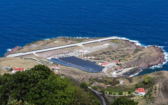
Juancho E. Yrausquin Airport is an airport on the Dutch Caribbean island of Saba.
Locations near Saba Island
The airport is close to The Bottom, Oranjestad, Philipsburg, Marigot, Gustavia, The Valley, Basseterre, Brades, Saint John's, Road Town, Charlotte Amalie, Ceiba, Yabucoa, Naguabo, Pointe-a-Pitre, Humacao, Fajardo, Basse-Terre, Arroyo, Las Piedras and other locations from U.S. Virgin Islands, Puerto Rico, Saint Martin, Guadeloupe, Montserrat, Sint Maarten, Antigua and Barbuda, British Virgin Islands, Saint Barthélemy, Saint Kitts and Nevis, Anguilla, Netherlands.
Direct flights from/to Saba SAB
These are all the active direct flights to Saba Island according to latest update at 24 April 2024 09:18:32. Check the flight's page for updated schedule and cheap airline tickets.
Meteo: Saba SAB

Windward Side
Partly cloudy
27℃
Feels like
30°
Wind
11.2 km/h
Humidity
89%
Visibility
10.0 km
Wednesday
24 April
24 April
27°
Moderate rain
Wind: 32.8 km/h
Thursday
25 April
25 April
27°
Patchy rain nearby
Wind: 30.2 km/h
Friday
26 April
26 April
27°
Patchy rain nearby
Wind: 30.2 km/h

Hotels
| Saba SAB
Airports near Saba SAB
Airlines flying
to Saba Island
Where to next?
There's a wide world waiting for you
Book now